

Drone Services
Construction Progression and Inspections.
About DroneScout
We’re an Ottawa based team of drone pilots, photographers, and videographers. Our job is to provide you with aerial images and data that your team or third-party experts can analyze to meet your specific needs.
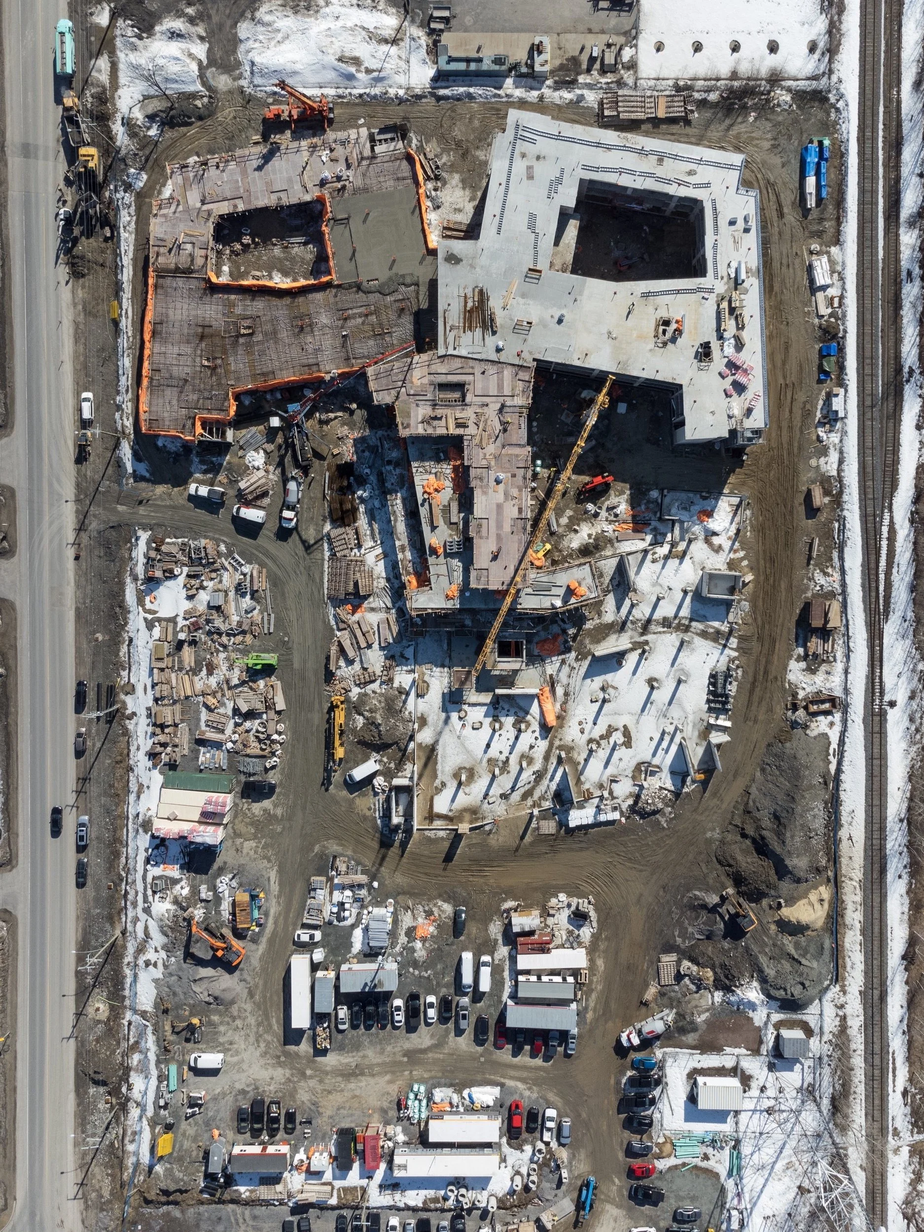
Construction Progression - Showcase project milestones and track construction progress with a variety of drone based solutions such as time lapse photos, before / after videos, 3D models, and orthomosaics.
Rapid Delivery Inspections - See what our drones see live, anywhere in the world, via our secure live-streaming platform.
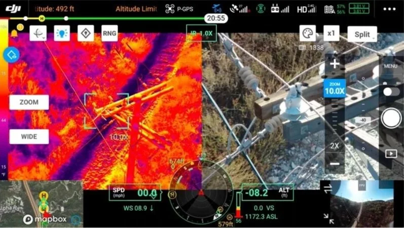
Advanced Technology - our drones are equipped with high resolution visual and thermal imaging cameras.
Safety First - Avoid risky manual inspections of rooftops, towers, and other challenging locations. Our pilots are licensed with Transport Canada and are fully insured.

Construction
Our drone-based services allow you to monitor progress, identify issues early, and keep stakeholders engaged with a wide variety of stunning visuals.
Our custom project webpages provide a seamless, interactive experience, empowering you to showcase every phase of your project in a professional and easy to use interface.
High-resolution before / after aerial photography
4K cinematic video footage
Orthomosaic maps for precise site overviews and progression tracking
3D models
Time-lapse videos tracking project evolution
Topographic surveys and digital elevation models
360° virtual tours for immersive exploration
Orthomosaic Mapping
Using drones equipped with high-resolution visual cameras, we capture detailed aerial data to create accurate maps your sites. Think of a Google map, but much higher resolution, and up to date.
Site Progress Tracking: Document construction phases or infrastructure changes with consistent, high-quality aerial views that highlight progress and potential issues.
Topographic Surveys: Generate 2D maps and 3D models of terrain, elevations, and features—ideal for land development, engineering, or environmental studies.
Thermal Mapping: Identify heat signatures across large areas, perfect for spotting energy inefficiencies, water leaks, or vegetation health in agricultural or industrial settings.

Inspections
Using drones equipped with high-resolution visual cameras and advanced thermal imaging, we provide comprehensive assessments of assets that are often difficult, dangerous, or costly to inspect from the ground.
Cell Towers and Communication Masts: Avoid the risks of climbing. We inspect tower components, antennas, and connections for damage, wear, or overheating—all while keeping your team safely on the ground.
Pipelines and Utility Lines: Monitor infrastructure for leaks, insulation failures, or vegetation encroachment. Our drones deliver high-definition visuals and thermal data to pinpoint problems fast.
Buildings and Rooftops: Evaluate structural integrity, roofing conditions, or HVAC performance without scaffolding or ladders. We spot water damage, heat loss, or wear that could compromise safety or efficiency.
How it Works
1. We deploy our drone to your site and being data collection.
2. You can see what the drone sees in real time via our secure live-streaming platform.
3. Receive your full set of images and videos immediately after the flight.
4. Hand off the data to your analysts or consultants for expert interpretation.
Data Capture for Expert Analysis
Our role is to supply you with data—images and videos—that your team or external specialists can evaluate to suit your unique requirements. While we don’t perform the analysis ourselves, we ensure you’re equipped with all the essentials to maximize its value.
Real-Time Insights with Livestreaming: Through our streaming service, clients can watch drone footage live as we fly. Whether you’re monitoring a site with your engineers, coordinating with inspectors, or sharing visuals with stakeholders, our livestream puts you in the front seat—no delays, no waiting.
Immediate Data Delivery: Once the flight is complete, we deliver your photos and videos right away, so you can start reviewing and acting on the data without downtime.
Versatile Applications: The footage we capture is perfect for a wide range of analyses—whether it’s structural engineers assessing bridge fatigue, energy auditors pinpointing heat loss, or maintenance teams planning repairs. Our drones provide the detailed, dual-perspective data that powers informed decisions.
Frequently Asked Questions
1. What services does Drone Scout provide?
We specialize in drone-based Construction applications. Specifically using a wide variety of visual deliverables to showcase and track progress milestones. Using drones equipped with high-resolution cameras and advanced thermal imaging, we capture data for infrastructure inspections. We provide the raw data—images and videos—for your team or third-party experts to analyze.
2. Do you provide data analysis?
No, we focus solely on capturing high-quality data. We deliver clear visual and thermal footage, photos, 2D maps and 3D models for you or your chosen analysts to interpret.
3. How does the real-time livestream work?
Our drones are able to stream live via a secure online platform, allowing you to watch inspections as they happen on any device with an internet connection. This is convenient for coordinating with your team, monitoring remotely, or sharing with stakeholders.
4. When do I receive the drone data?
We will deliver your photos and videos immediately after the flight.
5. What’s the difference between visual and thermal imaging?
Visual imaging provides detailed, high-definition pictures and videos of surfaces, ideal for spotting visible damage or tracking construction progress. Thermal imaging detects heat signatures, revealing hidden issues like leaks, electrical faults, or energy loss that aren’t visible to the naked eye.
6. What’s the difference between a drone map (or orthomosaic) and a normal photograph?
The difference lies in their purpose, creation, and level of detail. A photograph is a single image captured by a drone’s camera—whether visual or thermal—showing a specific view at one moment in time. It’s great for inspecting a particular spot, like a power line or rooftop, in high detail.
A drone map, on the other hand, is a comprehensive, stitched-together representation of a larger area. It’s built from hundreds of overlapping photos (and sometimes thermal images) taken during a systematic drone flight. These images are processed into a 2D map or 3D model that shows the entire site. You can think of the 2D map as a high resolution version of the satellite images you see on Google Maps.
While a photograph gives you a snapshot, a drone map gives you the full picture, ideal for planning, or tracking changes over time.
7. Can you map my property or project site?
Yes. Our drone mapping services create detailed 2D maps and 3D models using visual and thermal data.
12. Are your pilots certified?
Yes, our team consists of Transport Canada licensed drone pilots trained to operate safely and efficiently, complying with all relevant regulations.
Have a question we haven’t covered? Reach out—we’re here to help!
Contact Us